
Walking a Knox County Street
Start an address search with the exact number and street, not a broad guess about a neighborhood. Knox County separates the situs address, where the land sits, from the mailing address used for assessment notices and from the legal description that defines the parcel. For Knox County research, the Assessor supplies the current assessment lead, KGIS supplies the map context, and the Register of Deeds supplies the recorded title trail. Each result answers a narrower question than who is physically present at an address.
- Search the Knox County property system by situs address or parcel ID. Save the displayed owner, mailing address, tax year, legal description, and the date searched.
- Open the same parcel in KGIS Maps. Identify the parcel, then inspect nearby parcels, streets, subdivisions, ZIP, and district layers.
- Use the assessed owner and legal description to locate the latest grantee entry at the Knox County Register of Deeds. Record the instrument reference before moving backward.
- For a registration or polling question, use the state lookup with the required name, county, birth month, and birth year. It is not a browseable street roster.
- For an older address, consult McClung's reverse or criss-cross volumes and compare adjacent years before calling an address change a move.
That order keeps the work grounded in address-keyed evidence. A parcel card may suggest where tax mail went. A deed may show a transfer. Neither one proves every person who lived at the address.
Knox County Street Parcel Fields
The Knox County Assessor card is the practical starting point for Knox County address work because it joins a property address to a parcel record. The portal can show current owner, mailing and situs addresses, property class, neighborhood, living units, acres, utility and topography fields, additional owners, and legal fields. Newly recorded deeds can take about a week to appear. A different mailing address is a locate clue only, because it may belong to a business, relative, lender, attorney, or an older correspondence destination.
| Assessor field | Form | How it helps a street search |
|---|---|---|
| Owner name | Optional text route | Tests initials, suffixes, and an assessed ownership lead. |
| Property or situs address | Optional text route | Finds the physical street number and name. |
| Parcel ID | Structured text | Links the card to map, deed, and permit research. |
| Subdivision, lot, and plat | Legal-detail fields | Reconciles a platted parcel with the street address. |
| Tax year | Result display | Date-stamps information that can change. |
| Mailing address | Result field | Supplies a clue that must not be treated as occupancy proof. |
Knox parcel IDs are read through control map, group, parcel, and special-interest suffix components. Preserve the full ID. It can remain useful when a street number is changed, a subdivision phase is added, or an address search gives no match.
Knox County Street Views in KGIS
KGIS is the county, City of Knoxville, and KUB geographic layer. Its map searches Address, Parcel, Owner, Place, and Other. For an address, omit city, state, and ZIP first because the geocoder uses address points rather than street ranges. If a normal search fails, use Address Builder with the street and official house number, or return to the parcel and legal description. A map click can expose an owner, address, parcel ID, and a route to property reports.
Turn on parcels, buildings, streets, subdivisions, voting districts, school zones, city neighborhoods, ZIP codes, and aerials only when they answer the street question. For Knox County, KGIS lists historical aerial options from 1995 through 2022. Those layers can show a road extension, lot split, building change, or former structure. They do not identify residents.
Note: KGIS parcel lines are research aids, while an actual survey controls a boundary dispute.
Knox County Street Record Coverage
Address records do not carry the same weight. The table below separates Knox County public sources that can be searched by street or connected to a street through a parcel. Use the legal description and parcel ID as the bridge between them when a plain address stops working.
| Address record | Custodian | Street signal | Access path |
|---|---|---|---|
| Parcel card | Knox County Property Assessor | Assessed owner, mailing and situs address, CAMA and legal fields | Online card; office or TPRA route for older or corrected material |
| GIS parcel map | KGIS | Parcel geometry, adjacent parcels, districts, ZIP, aerial context | Public map and identify/report tools |
| Recorded deed | Register of Deeds | Grantor, grantee, date, legal description, instrument chain | Index and copy request; online cutoff was not stated |
| City work index | Knoxville Development Services | Permit, enforcement, request, status, date, parcel, or address | Online work search; historical report or TPRA fallback |
| Voter lookup | Tennessee and Knox Election Commission | Named registration match and polling information | Required-fields lookup; no public street-browse list |
| Historical directory | McClung Historical Collection | Year-specific address and occupant clue | On-site city, telephone, and reverse volumes |
The assessor and KGIS pair are the current address tools. The Register of Deeds and McClung collections add dated evidence. City records need a jurisdiction check first, since a Knox County mailing address may not be inside Knoxville city limits.
Knox County Street Deed Chains
Recorded deeds let a street search move backward through ownership. Begin with the current assessor owner and legal description, find the latest instrument where that person or entity is the grantee, then read the prior grantor, referenced instrument, book or page, and legal description. Search the prior owner as a grantee and repeat. Trusts, estates, spouses, corporate names, and “et al.” can all matter to the chain.
The Register of Deeds preserves Knox County's real-property record tradition from 1792 to the present. The Knox County office does not state a complete online index or image cutoff, so do not assume an absent online result means an absent deed. The office can provide copies in person or by mail, and its FAQ lists certified copies at $1 per page, subject to current confirmation. Older books and microfilm may require the Register or Knox County Archives.
The Register of Deeds recording and document page shows the real-property record types used in this step.

The recorded instrument, not a current assessment display, is the title evidence. Keep the instrument number, recording date, parties, legal description, and prior reference together for each link in the chain.
Knox County Street Permit Clues
For Knox County addresses inside Knoxville city limits, the advanced work search is the public address-keyed route for service requests, enforcement or investigation, work orders, permits, and engineering development. Search the main street name without a directional prefix or street type, or use a full parcel or CLT number with at least eight characters and no spaces or dashes. Opened-date ranges, status, and type help narrow a common address.
Results can load to a map or export to Excel. A details view can show request number, type, address, unit, parcel, description, open and status dates, status, and coordinates. Treat those as work-history facts. A named applicant or a building owner in a record does not establish occupancy or title.
Knoxville's advanced work search is the direct address and parcel interface for these city-side results.
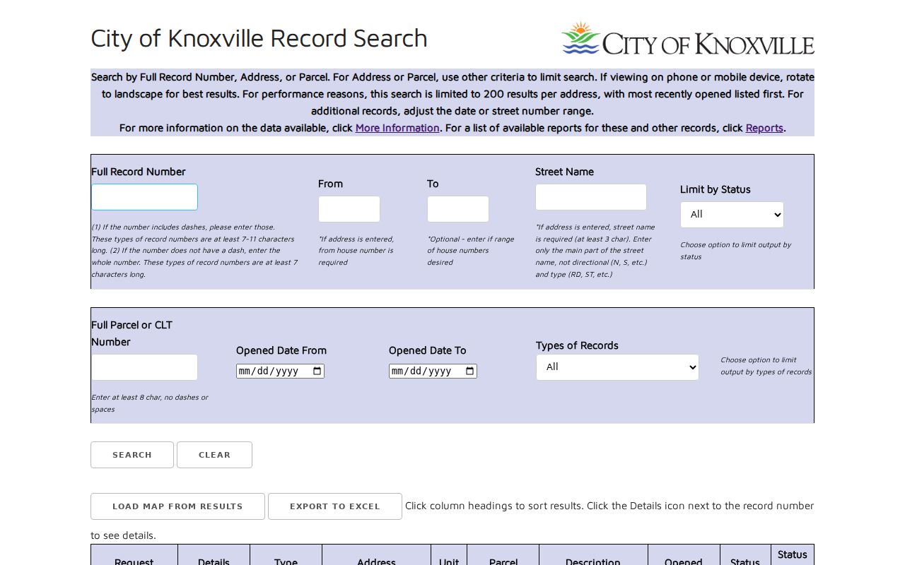
Plans Review & Inspections says its historical database is still being built. For a complete older file, use the Development Services records-request route or property report instead of assuming the online list is complete.
Note: A Knoxville property or address report is generally listed at $50, and the request should be directed to the proper city department.
Knox County Street Directory Terms
Knox County street work becomes much easier once the record vocabulary is kept straight. These terms describe different records, not different names for the same thing.
- Parcel
- A defined piece of land in the assessment and map systems, usually identified by a parcel ID.
- Situs address
- The physical address where a parcel sits, which can differ from the address used for tax mail.
- Plat
- A recorded subdivision map that can connect a street address to a lot, block, phase, and book or page reference.
- Criss-cross directory
- The address-ordered portion of a historical directory, used to find a dated occupant clue from a street number.
A legal description, including a lot or metes-and-bounds description, may survive a street spelling change more reliably than the number on a door. Save it before changing search routes.
Knox County Street Directory History
For Knox County address history, McClung's city-directory collection is the historical answer to an address question. The collection describes Knoxville city directories from 1859 to the present and telephone directories from 1898 onward, with individual volumes checked for gaps. The reverse or criss-cross section can move from an address to a year-specific occupant entry. Record the printed street name, house number, spouse or status notation, occupation field, and page before comparing a second year.
A disappearance from a reverse listing can reflect a renumbered street, a gap, an unlisted entry, a move, or a changed directory convention. Historic maps and the parcel's legal description help test those possibilities. The historical shelf and its volume-by-volume coverage are described in the Knox County city directories collection.
Knox County Street Voter Limits
The Tennessee Voter Registration Information Lookup requires county, first name, last name, birth month, and birth year. For Knox County, GoVoteTN can use name and ZIP or street address and ZIP to return registration and polling information. Those tools confirm a specific request. They do not provide a public list of every registered voter on a street.
The Knox Election Commission is the custodian for questions about a voter-file request, historical poll books, precinct material, fields, format, and use limits. A request should identify the election date or precinct and whether inspection, an electronic list, or certified copies are sought. T.C.A. §2-2-138 places restrictions on voter-list use, and Safe at Home participants use protected information rather than a residential address.
Knox County Street Address Geography
A Knoxville mailing address does not guarantee that a parcel lies within the City of Knoxville. KGIS serves the county, city, and KUB, while municipal permit and neighborhood sources apply inside city limits. Check KGIS boundary layers before routing an address to a city office. ZIP codes are mailing geography too, not parcel, school-zone, voting-precinct, or city-limit boundaries.
When an address search fails, retain the street core, current and older spelling, parcel ID, subdivision or lot, map or plat reference, legal description, and nearest cross street. KGIS recommends omitting city, state, and ZIP before retrying the geocoder. No verified countywide renumbering or street-renaming project was located, so address changes must be shown by the individual records rather than assumed.
Knox County Street Directory Limits
A street directory does not reveal a complete household. Other household members may not appear in a public ownership filing. KUB customer information is not a City of Knoxville record, DMV address data is protected, and juvenile, adoption, sealed, protected-voter, and Safe at Home material is not ordinary Knox County address-search information. A blank assessed-owner field can also be an “UNLISTED” display setting rather than proof that the ownership record vanished.
The useful conclusion is modest: a parcel and its public record trail can show ownership, map context, or a dated directory entry. It cannot safely establish everyone living along a Knox County street.